Bailiff Saw Mill & Ferry
Old Mills and the People Who Built and Operated Them on the Caney Fork River
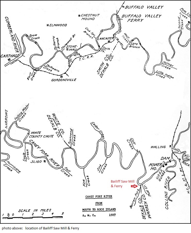
Bailiff Saw Mill on the Smallman & Swan property below the Great Falls Dam was located where the Webb School Camp was later established. It was at the mouth of Barren Fork Creek. Mr. James McGiboney stated that the mill was operating prior to 1847. His father had the lumber sawed out at the mill for his new house. He carried it up the hill (about 200 feet up a steep bluff) on his back and then carted it to his home. Cart referred to a 2-wheeled vehicle which Mr. McGiboney said a number of families owned. He added that very few owned wagons before the Civil War. A few people in the area had horses but most families depended on oxen.
The Caney Fork of the Cumberland
Recollections of James McGiboney
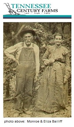
James McGiboney was born a short distance west of the present village of Campaign in 1847. He told the writer that he always understood that the was born about the time that John Cunningham of Rock Island, a Revolutionary soldier, died.
Mr. McGiboney knew the area around Rock Island from the time he was able to walk, having gone to the mill there as a small boy. The mill was located on the Island at its lower end. There was a timber dam at the lower end of the slough about 8 feet high. The old bridge across Caney Fork was nearly gone in his youth - only a few timbers remaining. The bridge just skirted the upper end of the Island with an opening in the side so that a person could either stop at the Island or go all the way across the river. The bridge was originally built by the Mayberry family. They operated it for several years until it got in rather bad repair. Peter Burem then took over, repaired the structure and operated it unto John B. Rodgers bought it, along with the surrounding land. Peter Burem (Buram) was a preacher and sometimes preached at Asbury.
As time passed the mill pond became full of silt and the mill rotted down until it stopped operating about 1866 or 1867. Other mills had been built in the mean time. The bridge had been a toll bridge.
Rock Island was a great place for picnics. They were held on the island. Mr. McGiboney remembered that the Rock Island ferry operated all the time during the Civil War.
In talking about the Iron Forge on Rocky River, Mr. McGiboney said that a corn mill was operated at the same location and that it was one of the first mills in that section of the country.
The area bounded by the Collins River and the Caney Fork from the mouth of the former to the Narrows was called the "Wilderness" and was the home of the Cunninghams. The old Cunningham Ford across Collins River was very rough.
The Iron Forge and mill were located on the left bank of Rocky River before (downstream from) the Rowland Ford.
In speaking of the Old Kentucky Road Mr. McGiboney said that going North and after crossing Falling Water Creek it bore off to the right to Algood and another branch turned left to Cookeville. Going South across Caney Fork River it followed the present McMinnville Road (Hgw. 70) to the Red Store (Junction of 70 & 30 to Spencer) and left Hgw. 70 crossing Collins River at Shell's Ford. It passed on to Viola and the Elk River and South to Alabama. In the early days it was used for transporting mules and slaves from Kentucky to the Alabama and Mississippi plantations.
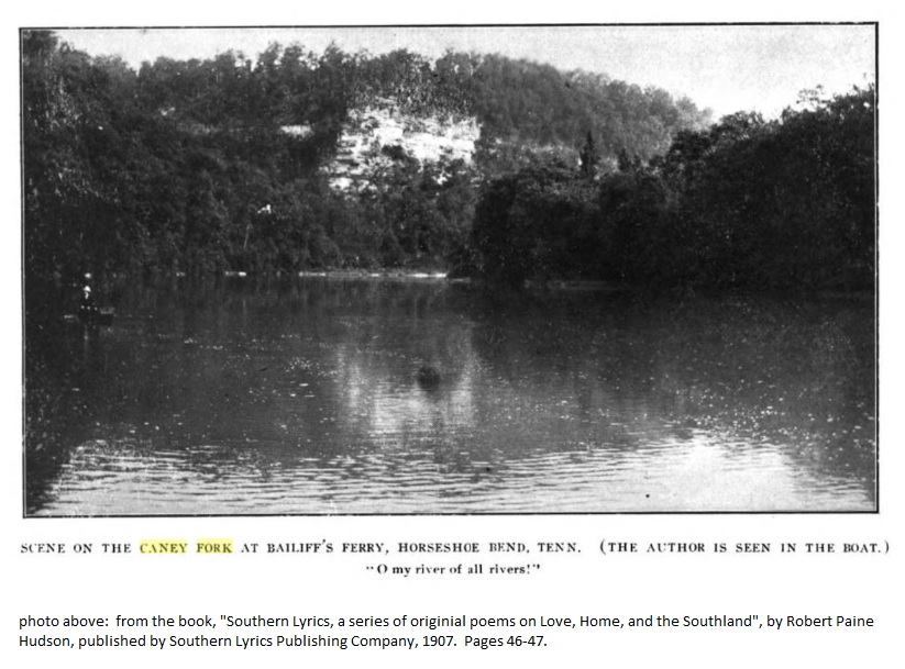
The pool of quiet waters just above Frank's Ferry was known as "Kings Eddy." Steam boats came up the Caney Fork as high as Frank's Ferry. The last one to make the trip sank on the return trip. After that Pin Hook was the head of navigation on the Caney Fork.
The saw mill at Bailiff Ferry (where the summer camp for Webb School was later established) was operating before 1847. Mr. McGiboney's father had lumber sawed out at the mill for his house. He packed it up the 200 foot bluff to the top of the hill on his back and then carted it to his home. There were some carts (2 wheels) but very few wagons in that part of the country before the Civil War. A few farmers owned horses but oxen were used for he most part for work on the farm.
Mr. McGiboney went on to tell about Yankee biscuits.
The Bosson Ford just above the present Great Falls Dam was not far above the Falls and was a rough ford. Mr. McGiboney said the first wagon he ever saw cross the river at that ford was a four-horse biscuit wagon belonging to the Yankee troops. After a fight above Sparta some of the troops in their retreat crossed at the Bosson Ford. The wagon came down the hill at a full gallop. It was hard on the wagon and many a young sapling was torn up by the roots. A short time later the axle broke near what is now Campaign and tins of biscuits were scattered over the road. At first the natives were afraid to touch the tins but as the Yankees had dashed off with the horses and did not come back for the wagon the local people gathered up all the biscuits and enjoyed eating Yankee food because the local flour supply was very limited. All the irons on the wagon were carried off as iron was also scarce.
Note: Mr. McGiboney built a sturdy, light weight, yellow poplar boat when he was 74 years old. He used 1/2 inch boards. The boat was used constantly during the construction of roads and bridges in the Reservoir area. It was powered with a 3 1/2 H.P. motor. It was light, easy to handle and with a paddle could be used in either quiet or rough shallow water.
The Caney Fork of the Cumberland
Ferries on the Caney Fork below Great Falls
Bailiff Ferry - often referred as "Old Bailiff Ferry" - 4 miles below Great Falls in Horseshoe Bend, where Webb School Camp was located in the 1930's. At one time called Cotton Ferry.
The Caney Fork of the Cumberland
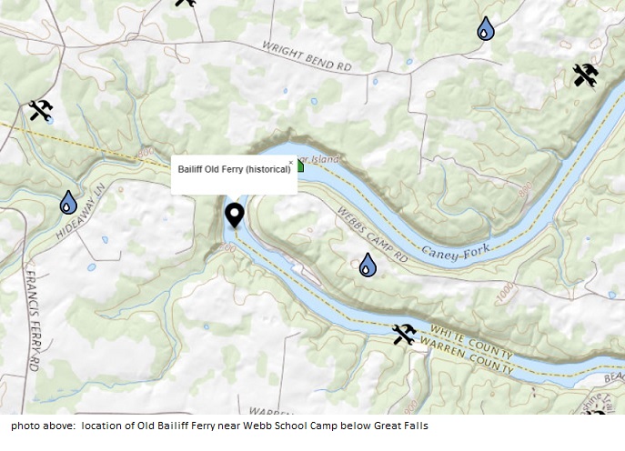
Webb School Camp moved to site of Old Bailiff Ferry
The name Horse Shoe Bend is derived from the actual shape of the lake, and dates back to 1794.
Four miles below Great Falls in Horse Shoe Bend is where Webb School Camp was located in the 1920's. The camp started as a "summer school" at or near the site of Hi-Lake Camp. The camp was organized and run by Profs. W.R. Webb and G.W. Follin of the famous Webb School located in Bell Buckle, TN.
Over the first ten years, the camp gradually changed from a summer school to a recreational camp. At the end of that period the camp was moved around 1918 to the well known site of Old Bailiff Ferry. The camp was closed in 1939.
History of Horse Shoe Bend Marina
Webb School Camp
This camp started as a "summer school" located near Walling and at or near the site of Hi-Lake Camp. The camp was organized and run by Pros. W.R. Webb and G.W. Follin of the famous Webb School at Bell Buckle, Tennessee. The emphasis in the early days was on Greek, Latin and Mathematics. Over the first ten years the camp gradually changed form a summer school to a recreational camp. At the end of the period the camp was moved (between 1918 & 1920) to the well known site at Old Bailiff Ferry about 3 miles downstream from the Power House by river and about 4 miles by road from Walling Station. Permanent wood buildings were erected at the new location. A large, cool spring provide an ample water supply for the camp and for cold showers.
There was a small farm adjoining the camp. Prof. Follin's son, Webb Follin, said that after a good rain the boys would search the cultivated fields for Indian relics. They found many different items which indicated that the Indians must have camped in the area for many years.
The Chattanooga Times of Sunday, June 23, 1935 carried a very fine article by Robert Sparks Walker describing the camp area and many of nature's wonders to be found in the vicinity of the camp. Venus Falls on Barren Creek, across the river, was one of the spots the boys liked to visit. Trips down the Caney Fork by canoe were among the summers high lights. A truck met the boys at Sligo and returned them to camp.
Webb Follin told the writer that their family spend each summer at the camp till he was grown. His mother looked after the diets provided in the dining room. He said that the Jack Fish were native to the Caney Fork and spawned each year close to the camp. He noted that they are now referred to as Walleyes.
The camp was closed in 1939
The Caney Fork of the Cumberland

Oil Region of Tennessee, Its Resources and Capabilities
Of all the water powers in the county, that on Caney Fork at the falls, if not the best, at least is the most powerful. This stream is one of the largest tributaries of the Upper Cumberland. Taking its rise on the Cumberland Mountain about eighteen miles east of Sparta it descends a deep, dark, narrow gorge, hemmed in by frowning cliffs for twelve or fifteen miles, when it debouches into an undulatory valley plain. Passing westward through this valley by many winding ways, it plunges, at Rock Island, over a silictous limestone, by a succession of falls and rapids, for two and a half miles.
At Rock Island, where the piers for the railroad bridge have been partly built, there is a fall of five feet, which might be increased by a dam any required heighth. From the island to the principal falls, a of about two miles, there is a fall of five feet. At this point the descends perpendicularly twenty five feet. Below the main fall, for 250 yards, there are rapids with a fall of six feet, when there occur successive falls within one hundred yards, each of about twenty feet. Then succeed rapids for thirty yards, with a fall of six feet. Below the rapids the water is eddy for 150 yards. Below the eddy water there are rapids for a hundred yards or more, with a fall of six feet. From this point to the principal falls, a distance of a quarter of a mile, the aggregate descent, as measured by Major Falconett, civil engineer, is 96 feet. Below the rapids last mentioned there is a succession of shoals, until at the distance of three miles the Horse Shoe falls occur, where there is a perpendicular descent of six feet. The current, from this place to Bailiff's mills, a distance of two miles, is rapid.
Four miles below, at Frank's ferry, is the head of steamboat navigation. At many places in the river the channel is compressed within a space of twenty yards, while at others it widens to one hundred yards or more. The average breadth of the stream is about seventy five yards.
The banks and bottom of this stream from Rock island to the foot of the rapids are composed, as before remarked, of ledges of hard siliceous rock which have withstood the erosion, while the softer rocks below, mainly the Trenton limestone and shale, have not been able fo resist the continued corroding action of the water.
Dams, by reason of such banks, can be made durable without any danger from undermining or a diversion of the stream by pressure around the ends. Material for their construction is cheap and convenient. The lay of the land for the erection of buildings is not good; high, overhanging bluffs or steep banks extending nearly all the way. Nevertheless, a few good sitts are found under the bluffs, and the water could be conveyed through artificial flumes below the falls two or three hundred yards, where the bluff gradually subsides into a comparative level surface.
It would be difficult to estimate the great power which could be developed at this place. It would come within the range of possibility to say that, throughout the entire distance from the foot of the rapids to Rock island, a distance of two miles and a half, a dam eight feet high could beconsiructed on an average for every four hundred yards, so as to secure a storage of at least 20 00,000 cubic feet of water. From the island to the last rapids, the velocity of the current would average not less than eight feet per second, while a section of the river in ordinary water below the island and above the principal falls, would give near 900 square feet. Upon this conjecture each dam would represent a 760 gross horse power, or the stream for the distance under consideration would furnish power equal to 9120 horses.
from the book, "Oil Region of Tennessee with some account of its other resources and capabilities", by J. B. Killebrew, Commissioner of Agriculture, Statistics and Mines. Printed by the American Printing Company, 1877. Pages 96-97.
![]() click on "arrow" to go back
click on "arrow" to go back